|
|
WARNING/DISCLAIMER: Hiking can be dangerous and the information furnished below may contain errors! |
Schunemunk Mountain: The Megaliths
Total Distance: 6.4 miles
Difficulty: strenuous (1,350'+
vertical rise, some rocky terrain)
Estimated hiking time: 5+ hours
(group)
The Sweet Clover (white blazes) and Jessup (yellow blazes) trails start opposite the parking area.
Take the combined Sweet Clover / Jessup trails. When they split, make a left onto the Sweet Clover trail. After a bit of a climb you will encounter the Jessup trail again. Make a left onto the Jessup trail. You will pass the Dark Hollow trail (black blazes on white backgrounds) on your left as you go.
Soon after passing the Dark Hollow trail you will see on your right white trail marks on rocks that will point / lead you west to the Megaliths (to the right). Follow the white marks / arrows and small white squares where they lead you to. Eat lunch!
Return to the Jessup trail using the same white trail that brought you to the Megaliths. Make a left onto the Jessup trail and walk north until you will intersect the Dark Hollow trail. Make a right onto the Dark Hollow trail. Just before the train tracks you will intersect the Otterkill trail (red blazes) on your left. Make a left onto the Otterkill trail.
After a very short while you will intersect the Sweet Clover trail. Make a right onto the Sweet Clover trail and take it back to your car (going back the same way you started the hike).
References: NY-NJ Trail Conference Map #114 (West Hudson Trails), Orange County map
Driving Directions from New York City
Take the George Washington Bridge to the Palisades Interstate Highway heading North. In about 19 miles exit the parkway at exit 9W onto the Thruway (Route 87/287) which heads west. About 24 miles later, exit the Thruway at exit 16.
Just after the toll booths at exit 16 veer right to take Route 32 north for about 7.5 miles until Pleasant Hill Road. Turn left onto Pleasant Hill Road (a sign for the "Black Rock Fish & Game Club" may be at this turn, it is also a left turn soon after Creamery Road).
This turn is easy to miss!After turning left onto Pleasant Hill Road, make the next left (onto Taylor Road) over a small bridge. Veer right at the next fork (do not turn onto Starr Road). Taylor Road crosses over the Thruway. From the initial left turn onto Pleasant Hill Road you will drive a total of about 0.35 to 0.4 miles until a small parking area ("P" in the upper right on the map below) on the right side of the road (park here, N 41.40762, W 074.08155).
The entire trip is about 60 miles and should take less than and hour and a quarter.
Click here for What to Bring on a Hike
Click here for Information for Group Hikes
Questions: Michael Brochstein
 |
 |
|
|
The parking area. (August 2001) |
The parking area. (August 2008) | |
 |
 |
|
| The start / end of the hike, opposite the parking area. Note the blazes for the Highlands, Jessup (yellow) and Sweet Clover (white) trails. (August 2008) | ||
 |
 |
|
| (August 2008) | (August 2008) | |
 |
 |
|
| Take (go left on) the (white) Sweet Clover Trail at the beginning of the hike and see this same junction towards the very end of the hike when you are again on the (white) Sweet Clover Trail on the way back to the parking area. (August 2008) | ||
 |
 |
|
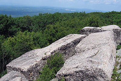
| Sign for the Megaliths at the beginning of the trail that leads to them (may not be easily visible!). (August 2008). | Some of the Megaliths (August 2008). | |
 |
 |
|
| (May 2012) | (August 2008) | |
 |
||
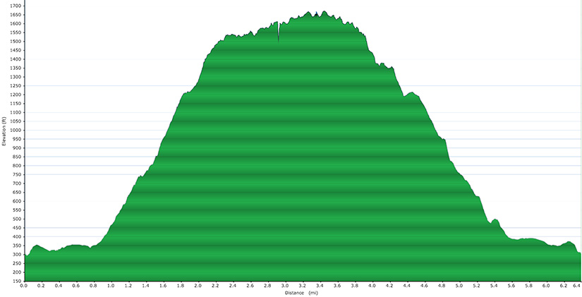
| It's not flat! (July 2010). | ||
 |
||
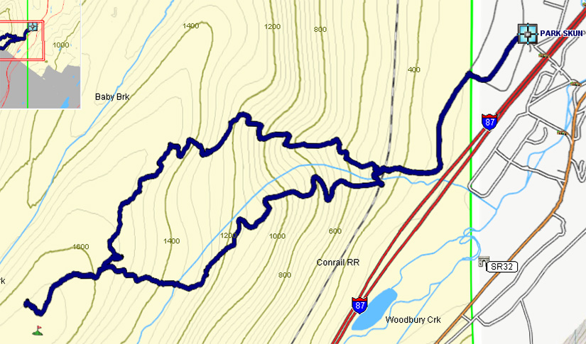
| Image courtesy of T. Parliment (May 2012) | ||
Last updated: 4/2015
Copyright © 2008-2012 Michael Brochstein. All rights reserved.