|
|
WARNING/DISCLAIMER: Hiking can be dangerous and the information furnished below may contain errors! |
Pyramid Mountain Hike
Total Distance: 5 miles
(700'+ elevation gain)
Difficulty: moderate
Estimated hiking time: 3 - 4 hours
Hiking Notes
From the north end of the parking area take the blue blazed trail westward (into the woods). Continue on the Blue blazed trail for a while (past the white blazed trail on your left) until you reach the combined yellow and blue blazed trails. Do not take the first right onto a yellow blazed trail that you will see soon after starting the hike.
Veer left onto the combined yellow and blue blazed trail and continue left on the yellow blazed trail when the blue trail goes off to the right. Follow this until the yellow trail ends and you reach the Blue & white blazed trail. Make a left onto the Blue & white blazed trail and continue (right) on the blue blazed trail when the white blazes go in a different direction.
After a while you will make a right onto a red (and white) blazed trail. Take this trail until you reach the intersection with the white blazed trail. Make a left onto the white blazed trail (heading northeast). In a little while, on your right there is an overlook and a great place to eat lunch. There is a very very short orange blazed trail on your right that goes to this overlook.
Turn around after lunch (retrace your steps and make a left onto the white trail) and now go southwest on the white blazed trail. Go past the red blazed trail on your right until you reach a blue blazed trail (just beyond Tripod Rock). Continue straight onto the blue blazed trail until you reach a blue & white side trail on the right. This short trail leads to Lucy’s Lookout. Take it and then retrace your steps back to the blue blazed trail and turn right to continue on the blue blazed trail.
When you reach the joint yellow/blue trail markings continue straight onto it (don’t turn right). Continue following the yellow trail when blue splits off. Take the yellow trail until its end where you see a blue trail again. Turn left onto the blue trail to go back to the parking area.
REFERENCES: Circuit Hikes in Northern NJ (4th Edition) p.63-67, NY-NJTC Map #31 (Pyramid Mountain Trails, circa 1991), and the best, up-to-date, downloadable and free maps available from the Morris County Park Commission (I recommend you download and use these!).
Driving Directions from NYC
Take the
George Washington Bridge to Route 80 West. Take Route 80 until exit 43 (Route 287). Take Route 287 North to Exit 44 (Main Street, Boonton). At the end of the exit ramp make a right, cross the bridge (over Route 287) and continue straight onto Main Street. Proceed straight (west) along Main Street and in a few blocks turn right (northward) onto County Route 511 (Boonton Avenue).Caution: Route 511 is not well marked! After 3.3 miles on Route 511 (about 0.8 mile north of the intersection of Route 511 and Taylortown Road) and opposite Mars Court (Park), you will find a sign for Pyramid Mountain and a Visitors Center on the left. Park in the parking lot for the Visitor's Center (on the left, GPS: N 40.94706, W 074.38736).
The total driving time is estimated to be under one hour without traffic and is about 43 miles.
Click here for What to Bring on a Hike
Click here for Information for Group Hikes
Questions: Michael Brochstein
 |
 |
|
|
The entrance to Pyramid Mountain County Park. (November 2007) |
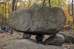
Tripod Rock (November 2007) |
|
|
|
||
|
The entrance to Pyramid Mountain. Note that the brown and white sign has been replaced by the new green and white one pictured above. (August 2001) |
||
 |
||
| Elevation profile for hike done in reverse direction. | ||
Other Useful Information
We are meeting, promptly, at 8:00am in front of TBA. Drivers should double park their cars in front of the building (please gas up BEFORE coming). All passengers are expected to contribute their fair share towards gas, parking fees, and tolls! We will return to the city in mid to late afternoon. Rain cancels the trip.
Reverse Direction Hiking Notes
(less popular as it puts the obvious lunch spots towards the earlier parts
of the hike)
From the parking area take the access trail to the blue blazed trail. Follow it until you turn right onto the yellow blazed trail. When you reach the blue blazed trail, follow the joint yellow-blue trail. When they split, turn right and follow the blue blazed trail.
Just past this point is a blue & white side trail on the left. This short trail leads to Lucy's Lookout. Retrace your steps back to the blue blazed trail and turn left to continue on it.
When you reach the intersection of the white blazed trail continue straight ahead (north) on the white trail. Go straight on the white blazed trail past the red blazed trail on your left to the overlook on the right. Eat lunch here. Return to the red blazed trail and make a right onto it.
Turn left onto the blue blazed trail when you reach it. From Bear Rock turn left and follow the blue and white blazed trail. Turn right onto the yellow blazed trail. Turn right onto the blue blazed trail. Finally, follow the access trail (right turn from blue trail) back to your car.
Last updated: 11/2007
