|
|
WARNING/DISCLAIMER: Hiking can be dangerous and the information furnished below may contain errors! |
Schunemunk Mountain Hike
Total Distance:
9.6 milesThe re-re-routed Jessup Trail (yellow blazes) starts opposite the parking area (which is also where the hike ends).
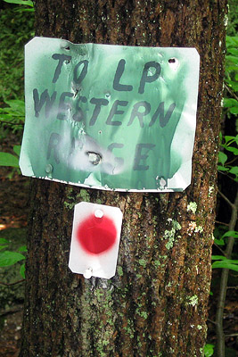
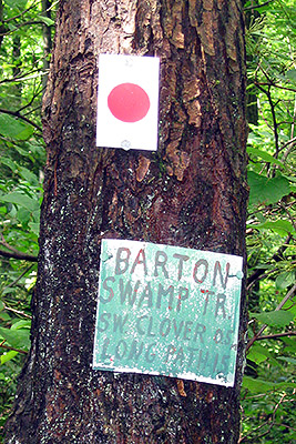
After about two miles, at a 4-way trail intersection, the Barton Swamp Trail (red blazes) forks right. Make a right onto this trail (there is a sign saying "To LP, Western Ridge" near here. If you see a sign that mentions the Barton Swamp trail then you've missed the right turn). After a while you will veer left onto the Long Path (blue blazes) heading south. Take the Long Path until you intersect the Jessup Trail (yellow blazes).
About three miles from where you last left the Jessup trail turn left to (again) go onto the Jessup Trail (there may be both yellow and blue blazes but it is the yellow blazes that indicates the Jessup trail). Just beyond the peak (1664') white marks on the rocks will point west to the Megaliths (to the left). Follow the white arrows and small white squares where they lead you to.
A short while after returning to the Jessup trail and continuing north (the direction you had been going), you will intersect the black dot on white blazed Dark Hollow trail. Stay on the Jessup trail. Turn right onto the Sweet Clover trail (white blazes, this turn is not well marked!). The trail emerges besides railroad tracks (fast trains run here throughout the day!). Go across the tracks and and continue on the Sweet Clover trail. While staying on the Sweet Clover trail, make a left onto the (second) dirt road when you get to the beginning of the open field (before the highway). This will be the second dirt road you will pass after the train tracks (the first one comes soon after crossing the tracks). Take the Sweet Clover trail back to your car.
References: NY-NJ Trail Conference Map #114 (West Hudson Trails), Orange County map
Driving Directions from New York City
Take the George Washington Bridge to the Palisades Interstate Highway heading North. In about 19 miles exit the parkway at exit 9W onto the Thruway (Route 87/287) which heads west. About 24 miles later, exit the Thruway at exit 16.
Just after the toll booths at exit 16 veer right to take Route 32 north for about 7.5 miles until Pleasant Hill Road. Turn left onto Pleasant Hill Road (a sign for the "Black Rock Fish & Game Club" may be at this turn, it is also a left turn soon after Creamery Road).
This turn is easy to miss!After turning left onto Pleasant Hill Road, make the next left (onto Taylor Road) over a small bridge. Veer right at the next fork (do not turn onto Starr Road). Taylor Road crosses over the Thruway. From the initial left turn onto Pleasant Hill Road you will drive a total of about 0.35 to 0.4 miles until a small parking area ("P" in the upper right on the map below) on the right side of the road (park here, N 41.40762, W 074.08155).
The entire trip is about 60 miles and should take less than and hour and a quarter.
Click here for What to Bring on a Hike
Click here for Information for Group Hikes
Questions: Michael Brochstein
 |
 |
|
|
The parking area. (August 2001) |
The parking area. (August 2008) | |
 |
 |
|
| The start / end of the hike, opposite the parking area. (August 2008) | ||
 |
 |
|
| (August 2008) | (August 2008) | |
 |
 |
|
| Go straight on the (yellow) Jessup Trail at the beginning of the hike and see this same junction towards the very end of the hike when you are on the (white) Sweet Clover Trail on the way back to the parking area. (August 2008) | ||
 |
 |
|
| You should see this sign. It means you are on the Barton Swamp trail heading north (August 2008). | You should not see this sign. It means you are on the Barton Swamp trail heading south (August 2008). | |
 |
 |
|
| Sign for the Megaliths at the beginning of the trail that leads to them. (August 2008). | Some of the Megaliths (August 2008). | |
 |
 |
|
| (August 2008) | (August 2008) | |
 |
||
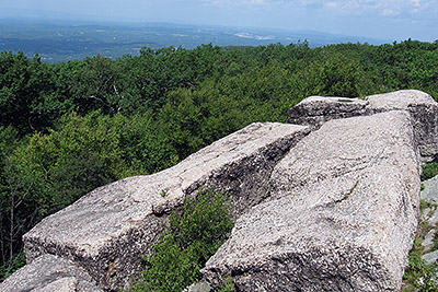
| It's not flat! (August 2008). | ||
Last updated: 8/2008