|
|
WARNING/DISCLAIMER: Hiking can be dangerous and the information furnished below may contain errors! |
Hiking in Harriman State Park:
Southfields Circular
See below for important news regarding one of the parking areas.
Total Distance: approximately (8 or) 10.25 miles
Difficulty: Medium plus (medium hills)
Estimated hiking time: 5.5+ hours (~6.5+ group)
Take the Nurian trail (white blazes) which starts at the northeast end corner of the parking lot (walk north next to the train tracks). At the end of the Nurian trail, make a left onto the Ramapo-Dunderberg trail (red on white blazes). Make a left onto the Lichen Trail (blue "L" on white) and then a left onto the Arden-Surebridge (A-SB, red triangle on white blazes) which at this point is also the Long Path (aqua blazes).
When the A-SB meets the Appalachian Trail (AT, white blazes) continue straight on the combined trail and when they split, continue on the AT (heading westward/south). Make a left just before the Elk Pen parking area off the AT and onto "Old Arden Road" (marked "Arden Road" on the trail map). When you meet the A-SB again continue straight on Arden Road (veering right at any fork so that you be parallel to the thruway on your right until you meet the Nurian trail). Take the combined Old Arden Road and Nurian trail south back to the bridge over the thruway and then back to the parking area by the Red Apple Rest.
Shorter Alternative: Leave one car at Elk Pen (GPS: N 41.26534, W 74.15363). This will reduce the hike to approximately 8 miles. From the Red Apple Rest, drive north about 2 miles on Route 17 to Arden Valley Road. Make a right and go 0.5 miles until a parking area turnoff on your right.
References: NY-NJTC Trail Map #4 (Harriman-Bear Mountain. Trails)
Driving Directions from New York City
Take the George Washington Bridge to the Palisades Interstate Highway heading North.
In about 19 miles exit the parkway at exit 9W onto the Thruway (Route 87/287) which heads west. About 10 miles later, exit the Thruway at exit 15A. At the exit turn left onto Route 17 North.
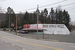
After about 8.5 miles, in the town of Southfields, you will see the Red Apple Rest on your right. Park in the northeast (far) corner of the large parking lot by a low stone wall (GPS: N 41.24124, W 74.17555). The entire trip is about 45 miles and should take less than an hour.
Public Transportation
From the Port Authority in New York City there is a bus that leaves people off in front of the Red Apple Rest as well as on Route 17 near Elk Pen.
Click here for What to Bring on a Hike
Click here for Information for Group Hikes
Questions: Michael Brochstein
|
|
 |
|
|
The Red Apple Rest on Route 17 (northbound view). |
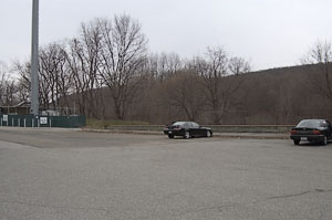
Northeast corner of parking area behind the Red Apple Rest. | |
 |
 |
|
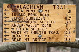
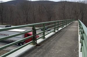
| Sign on the Appalachian Trail near the junction of the AT and Arden Road, just east of the Elk Pen parking area. | Bridge over the New York Thruway (Route 87) on the Nurian trail. | |
|
|
 |
|
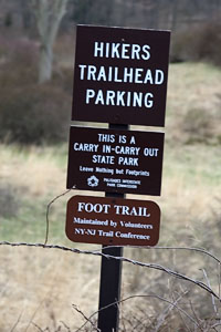
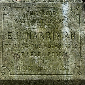
| Sign just outside the Elk Pen parking area. | 1894 Road Monument on Arden Road; "This road was built in 1894 by E.H. Harriman to show the advantages of level roads in hilly country." | |
 |
|
|
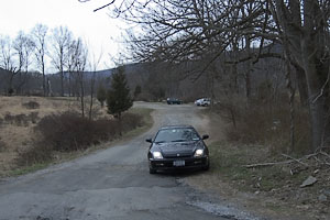
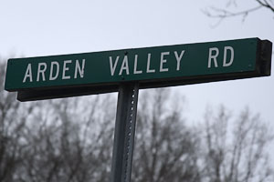
| Arden Valley Road sign at turnoff from Route 17 North. | Road leading into the Elk Pen parking area from Arden Valley Road. | |
Last updated: 1/2005
*** News
Regarding the Red Apple Rest parking area ***
(also posted on the NY-NJTC website at
http://www.nynjtc.org./trails/closed/index.html on 11/12/04)
Until further notice there will be no free hiker parking at the Red Apple Rest parking lot. This parking area is being converted into a commuter parking lot for permit holders. There is no other public parking in the immediate area.
However Red Apple Rest parking is closed only for full day parking but is
still open and available as a gathering place for hikes going further north
(as to Storm King, Schunemunk and the Catskills) as long as no cars are left
for the day; to hikers who want to have a bite to eat while waiting for groups
to gather. The restrooms are available to customers; and it is still an active
bus stop.
The nearest parking for hikers is at the "Elk Pen", approximately 3/4 mi. to
the north off Rt. 17. See NYNJTC Map #4-Northern Harriman-Bear Mt. Trails.
Accordingly, the NY-NJ Trail Conference has temporarily rerouted the western
end of the Nurian Trail (white) to co-align with road traces going south on
Arden Road from the Arden Surebridge Trail (ASB-red on white), and then east
after passing over a bridge, to connect back to the existing Nurian near the
northern end of Lake Stahahe. The Nurian going west from that point will be
closed indefinitely.
Paving of the Wild Cat Mt. trail head parking lot (Rt. 17a ) has been postponed by the Dept. of Transportation until approx. May 05', Consequently, there will be no parking prohibition there this winter. While drainage construction will be performed at the southern end of the lot, it will not prohibit trail head parking at he northern end.